
G reater than 2,800 flights have already been canceled due to Hurricane Matthew, whose maximum sustained winds are clocked at a speed of 120 miles per hour. The storm has weakened somewhat again to a Category 3 storm after it had strengthened again to Category 4 status; but it is not expected to strengthen again anytime soon due to the increase in its central pressure to 944 millibars or 27.86 inches.
The forward motion of Hurricane Matthew is only at 13 miles per hour to the north northwest, its effects are pronounced — meaning more time for torrential rains which are causing catastrophic flooding, longer periods of damaging winds, and rougher surf pounding coastlines.
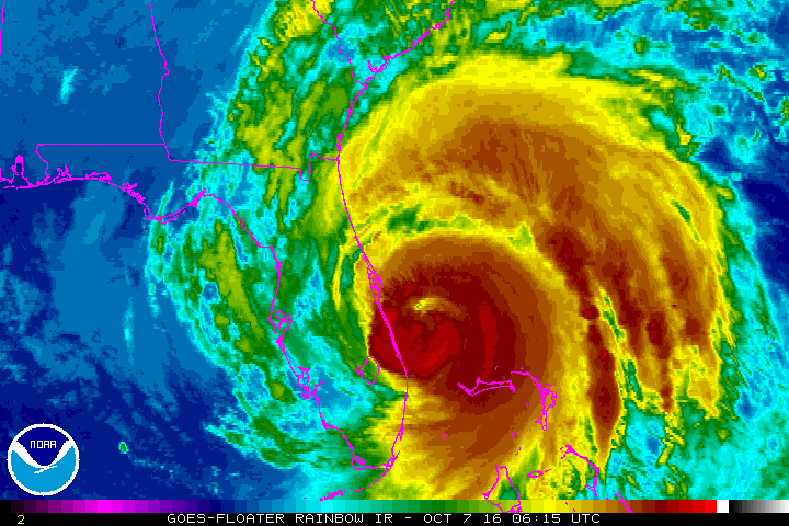
Hurricane Matthew Travel Alert Update: Southeastern Coast of the United States Feeling the Impact
When the theme parks of Orlando — including Walt Disney World, SeaWorld and Universal Studios — close due to a hurricane, you know that the potential for destruction is serious, as their closings are considered rare. Many sporting events have also been canceled or postponed.
At least one person has died in the United States as a result of Hurricane Matthew; and some news reports place the death toll at 478 in at least five countries — most of the deaths reported in Haiti, where the death toll is expected to continue to increase in what is becoming another significant humanitarian disaster since the devastating earthquake in 2010, as people who did not heed the warnings of the impending storm are currently missing; tens of thousands of homes have been damaged or destroyed; power is out in many places; a bridge connecting southern Haiti with the rest of the country was washed out; some towns were virtually wiped out; and some portions of the country may have experienced as much as 40 inches of rain.
Needless to say, travel to Haiti is not advised at this time; and there may still be interruptions and delays in travel to eastern Cuba, eastern Jamaica, and the Bahamas.

Additionally, you may want to consider delaying your travel if the southeastern coast of the United States is in your travel plans over the next several days — or, at least, keep yourself updated as to the latest information pertaining to the weather as a result of Hurricane Matthew, which nipped southwestern Haiti and passed by the eastern shores of Jamaica before passing over the easternmost tip of Cuba and tearing through the Bahamas.
Some coastal areas of the southeastern United States may see waves as high as 20 feet; while other areas could experience as much as 15 inches of rain. Tens of thousands of people in Florida alone have lost electric power. There may be localized spots of extreme damage along the immediate coastal areas; whereas only several miles inland can experience minimal impact from the hurricane.
Charleston in South Carolina is still currently on the north side of the storm; and massive amounts of water swept into the coast by Hurricane Matthew — combined with the confluence of swollen rivers and high tide — is expected to create a significant flooding event.
The worst of the storm has already occurred in coastal areas which are already south of the storm; but there may still be some significant wind gusts and sporadic strong squalls with heavy rain.
Bizarre Facts Pertaining to Hurricane Matthew
One of the bizarre facts about Hurricane Matthew is that it is taking a track which has never been recorded by other hurricanes in the entire history of the official tracking of hurricanes, as it is “hugging” along the coastline with the potential for landfall anywhere from northeastern Florida to southeastern North Carolina — and although it has not happened yet in the United States, the landfall of Hurricane Matthew could occur more than once along the way. Cities such as Jacksonville and Savannah are not used to major hurricanes; as for a major hurricane to affect that portion of the southeastern coast of the United States is extremely unusual. In fact, Hurricane Matthew is the strongest storm to affect that area since Hurricane David back in 1979.
Additionally, Hurricane Matthew is expected to turn to the east prior to reaching the outer banks of North Carolina. This is due to a high pressure system which has developed over the northern United States, which is preventing the storm from moving further north as was originally expected; but the hurricane may loop around in a complete circle and possibly affect the northern Bahamas and the east coast of Florida again due to the steering currents generated by Hurricane Nicole, which is off to the east out over the open Atlantic Ocean and will not affect the United States. Hurricane Matthew should be significantly weakened if it indeed does loop around, as it cooled the temperature of the waters in which it passed over and therefore provide less “fuel” for the storm to strengthen.
Weather Watches, Warnings, Alerts and Emergencies
Weather alerts and states of emergencies continue to be in effect for Florida, Georgia, South Carolina and North Carolina due to the distinct possibility of surging seas, locally damaging winds, flooding rains, beach erosion, strong rip currents and rough surf. Power outages and travel disruptions are almost a certainty as a result of the impact of the storm.
A hurricane warning is currently in effect for the following locations:
- Sebastian Inlet to South Santee River
A tropical storm warning is currently in effect for the following locations:
- Jupiter Inlet to Sebastian Inlet
- Anclote River to Suwannee River
- North of South Santee River to Surf City
A tropical storm watch is currently in effect for the following location:
- Anna Maria Island to Anclote River
These weather watches and warnings can change at any time as determined by the progress of Hurricane Matthew; so keep yourself updated with the latest information if you are to be affected.
Flight Waivers, Delays and Cancellations
If you are traveling to anywhere in the Bahamas or the entire east coast of the United States over the next week or so, expect delays and cancellations. Keep up to date on the latest information pertaining to these tropical systems which may adversely affect your travel plans. Better yet, postponing or canceling your trip might be a better option — no matter which mode of travel you plan on taking.
If you have a flight scheduled, your flight will most likely be delayed or canceled — and you may be eligible for a waiver of a fee to change your itinerary. If you are driving in any of these areas, watch out for deteriorating weather conditions and traffic problems.
Here are eight airlines which have issued travel alerts as a result of Hurricane Matthew:
- Delta Air Lines
- American Airlines
- JetBlue Airways
- United Airlines
- Southwest Airlines
- Frontier Airlines
- Spirit Airlines
- Allegiant Air
If you are stranded due to Hurricane Matthew, you need to find a place to stay — but many hotel and resort properties might already have no vacancies. “For those trying to put distance between themselves and Hurricane Matthew though, they are having difficulty finding alternate accommodations when it comes to settling in for the night/weekend”, according to this article — which offers advice on what to do in order to find a place to stay if you are an evacuee of the hurricane — written by Melinda Danielsen of Magic of Miles. “Rather than searching website after website to see which hotels remain open and still have room, a few special websites have emerged with consolidated data.”
If you are seeking to escape areas which are expected to be significantly impacted by Hurricane Matthew, choose routes as far to the west as possible. For example, take Interstate 75 north instead of Interstate 95 north.
FlyerTalk members have been discussing Hurricane Matthew in the following discussions:
- Hurricane Matthew: Check in here Community Buzz
- Weather waiver issued – Hurricane Matthew (Southeast U.S.) United Airlines | MileagePlus
- Hurricane Matthew Master Thread Delta Air Lines | SkyMiles
- Hurricane Matthew Disruption British Airways | Executive Club
- Hurricane Matthew Southwest Airlines | Rapid Rewards
- Hurricane Matthew Finnair | Finnair Plus
- Weather waiver due to Hurricane Matthew approaching Jamaica, Cuba, and the Bahamas Air Canada | Aeroplan
Summary
The aforementioned alerts widely vary by airline; so be sure to contact your airline or transportation provider for the latest information pertaining to your travels — if they are adversely affected — and please: travel safely.
Source: The National Oceanic and Atmospheric Administration of the Department of Commerce of the United States.
